Location
The country is located in northwestern South America. Its bordered by Panama and The Atlantic Ocean on its west, Venezuela and Brazil on its east, to the south by Equador and Peru and to its north is the Caribbean Sea. On the map its geographic coordinates is 4 00 N and 72 00 W.
Natural Regions
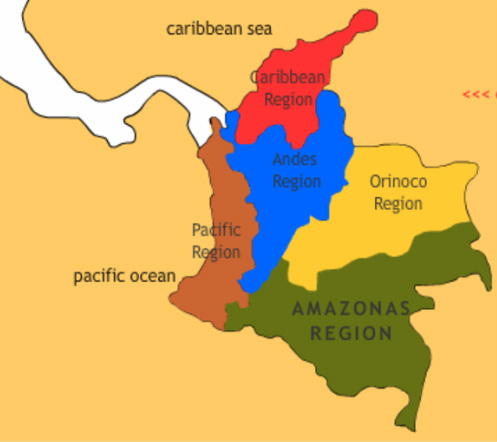
The Caribbean :

The Caribbean Region or Caribbean Coast Region is a natural region of Columbia mainly composed of eight Departments located contiguous to the Caribbean. The area covers a total land area of 132,288 km2 (51,077 sq mi) including the San Andres land Archipelago of San Andrés, Providencia and Santa Catalina in the Caribbean sea and corresponding to approximately 1/10 of the total territory of Colombia. The Caribbean region of Colombia is home to approximately 9 million people according to the Colombian Census 2005.
The area is characterized for having a massive plain that extends from the Colombian Andean Mountain range to the Guajira Peninsula that borders the Caribbean sea. In the western side of the region there is also a relative low altitude mountain range, the Montes de Maria which are also separate from the Andean mountain range. The Caribbean region is crossed by many rivers and contains one of the largest marshes in Colombia. The Ciénaga Grande de Santa Marta marsh among many others. The main river is the Magdalena River which is fully navigable in the region and a major path for the flow of shipments from and for inland Colombia. The Madgalena river has numerous sub basins within its basin.
The area is characterized for having a massive plain that extends from the Colombian Andean Mountain range to the Guajira Peninsula that borders the Caribbean sea. In the western side of the region there is also a relative low altitude mountain range, the Montes de Maria which are also separate from the Andean mountain range. The Caribbean region is crossed by many rivers and contains one of the largest marshes in Colombia. The Ciénaga Grande de Santa Marta marsh among many others. The main river is the Magdalena River which is fully navigable in the region and a major path for the flow of shipments from and for inland Colombia. The Madgalena river has numerous sub basins within its basin.
The Andes :

The Andes mountains form the most populated region of Colombia and contain the majority of the country's urban centres.They were also the location of the most significant pre-Columbian indigenous settlement. Beyond the Colombian Massif in the south-western departments of Cauca and Nariño, the Colombian Andes divide into three branches known as "cordilleras" (from the Spanish for Mountain Range): the Cordillera Occidental runs adjacent to the Pacific coast and includes the city of Cali; the Cordillera Central runs up the centre of the country between the Cauca and Magdalena river valleys (to the west and east respectively) and includes the cities of Medellín, Manizales and Pereira; and the Cordillera Oriental extends north-east towards the Guajira Peninsula, and includes Bogotá, Bucaramanga and Cúcuta.
The climate and vegetation of the region vary considerably according to altitude, but as a general rule the land can be divided into the tierra caliente (hot land) of river valleys and basins below 1,000 m; the more temperate conditions of the tierra templada (temperate land, approximately 1,000 m to 2,000 m) and tierra fría (cold land, 2,000 m to 3,200 m), which include the most productive land and the majority of the population; and the alpine conditions of the zona forestada (forested zone, 3,200 m to 3,900 m), páramos (3,900 m to 4,600 m) and tierra helada (frozen land, 4,600 m and above).
The climate and vegetation of the region vary considerably according to altitude, but as a general rule the land can be divided into the tierra caliente (hot land) of river valleys and basins below 1,000 m; the more temperate conditions of the tierra templada (temperate land, approximately 1,000 m to 2,000 m) and tierra fría (cold land, 2,000 m to 3,200 m), which include the most productive land and the majority of the population; and the alpine conditions of the zona forestada (forested zone, 3,200 m to 3,900 m), páramos (3,900 m to 4,600 m) and tierra helada (frozen land, 4,600 m and above).
The Pacific Coast :

The Pacific coast of Colombia extends to the west of the Cordillera Occidental, the westernmost branch of the South American Andes. The region, known for its heavy rainfall, numerous rivers, and luxuriant vegetation, remains mostly uninhabited and undeveloped. No roads reach this coast, so access is only by boat. Overland access from the interior of the country is only possible to the cities of Buenaventura and Tumaco, the main commerce centers of the region.
The Pacific Coast of Colombia is an active seismic zone with a well-documented record of high-magnitude earthquakes. Seismic observations for the past century record at least three M 7.9 seismic events (1906, 1979, 1992), accompanied by co-seismic subsidence, soil liquefaction, and extensive landsliding that caused abundant river damming. The 1906 and 1979 events caused littoral co-seismic subsidence up to 1.5 m along the southern Pacific Coast between Buenaventura and the Mira delta. Both events triggered tsunami waves 2.5 m high that caused more than 3,500 deaths of inhabitants of the low coastal areas.
Climate of the Pacific Coast is humid tropical, dominated by the annual migration of the Intertropical Convergence Zone (ITCZ) and by high relief associated with the Cordillera Occidental. Mean daily temperatures are about 26ºC with minimum values of about 14ºC. Annual rainfall reaches a maximum of about 10 m at the Buenaventura-San Juan River delta area, and decreases to the north and south to about 3 m/yr at the Panamá border and at the Tumaco-Mira River delta area. El Niño events regularly cause noticeable anomalies in rainfall, ocean-surface temperature, and sea level along the Pacific coast of Colombia. The 1997-1998 event was the most intense of the 20th century.
The Orinoco :

It is also known as The Eastern Plains from the Spanish Llanos Orientales. The region covers most of the area of the departments of Meta, Arauca, Casanare and Vichada. The region is rich in oil and is apt for extensive ranching.There the typical dance in spanish is the "joropo"dance.The Orinoquía is the area covered by the Orinoco river hydrographic basin. With more than 2.140 kilometers long and an average water flow of 39.000 M3/sec. The Orinoco during the rainy season reaches a width of 22 kilometers at San Rafael de Barrancas and a depth of 100 meters. Its territory extension has an area over one million square kilometers, of which 65% is in Venezuela and 35% in Colombia.
The Amazon :

This beautiful region is located at the southeast of Colombia.The Amazon river and its surrounding belongs to the most part to the Matto Grosso in Brazil. It is known as the lung of the world, since it is the most important fountain of oxygen for the planet.Colombia is well known by his biodiversity in Flora and Fauna, natural richness provided by the characteristics of the different region that conform Colombia, the Amazon region is one of them. The climatic and ambient condition make this region rich in Fauna and Flora, different to those ones found in the Andes region.
The Amazon region is almost the 40% of the Colombian territory, in addition is the less populated area of the country.Its territory is flat with jungles. It has a part known as the amazonic "piedemonte" because is located next to the east mountain range.
The Amazon region is rich in ethnics groups, while the most part of his population are indians that preserve their customs, language, culture and traditions. They have always been living in harmony with its surrounding. They work hard in the preservation of the Amazon region. We can mention nukaks (they are nomads), los ticunas, los tucanos, los camsás, los huitotos, los yaguas and los ingas.
Some of the capitals of the states belonging to the amazon region are connected through roads like San José de Guaviare, Mocoa and Florencia. The other connection paths are the river and the use of planes, helping in this way to reduce the impact in the region and preserving the Amazon region as a Worldnatural reservation and lung of the world.
For this reason the Amazon region is an ideal destination for the ecotourism lovers, they are many beauties still to be discover in this place
Climate
The climate of Colombia is characterized for being tropical and isothermal as a result of its geographical location near the Equator. Each region maintains an average temperature throughout the year only presenting variables determined by precipitation during a rainy season caused by the Inter-tropical Convergence Zone.
Flora and Fauna
Altitude affects not only temperature, but also vegetation. In fact, altitude is one of the most important influences on vegetation patterns in Colombia. The mountainous parts of the country can be divided into several vegetation zones according to altitude, although the altitude limits of each zone may vary somewhat depending on the latitude.
The "tierra caliente" (hot land), below 3,300 ft, is the zone of tropical crops such as bananas. The tierra templada (temperate land), extending from an altitude of 3,300 to 6,600 ft (1,006 to 2,012 m), is the zone of coffee and maize. Wheat and potatoes dominate in the "tierra fría" (cold land), at altitudes from 6,600 to 10,500 ft. In the "zona forestada" (forested zone), which is located between 10,500 and 12,800 ft, many of the trees have been cut for firewood. Treeless pastures dominate the páramos, or alpine grasslands, at altitudes of 12,800 to 15,100 ft. Above 15,100 ft, where temperatures are below freezing, is the "tierra helada", a zone of permanent snow and ice.
Vegetation also responds to rainfall patterns. A scrub woodland of scattered trees and bushes dominates the semiarid northeast. To the south, savannah (tropical grassland) vegetation covers the Colombian portion of the llanos. The rainy areas in the southeast are blanketed by tropical rainforest. In the mountains, the spotty patterns of precipitation in alpine areas complicate vegetation patterns. The rainy side of a mountain may be lush and green, while the other side, in the rain shadow, may be parched.
Environmental Issues
The main environmental issues affecting Colombia are deforestation.(soil and water quality damage from overuse of pesticides, air pollution, especially in Bogota from vehicle emissions and other main cities.) The collateral damaged produced by attacks against oil pipeline infrastructure by rebel guerrillas in the Colombian armed conflict has produced long term damage to the environment. The armed groups also deforest large areas to cultivate illegal crops and open unauthorized highways in protected areas.
